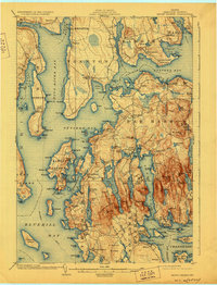
1904 Map of Mount Desert
USGS Topo · Published 1928About this map
Lafayette National Park anchors this coastal survey, showing the intricate shoreline and mountainous interior of Mount Desert Island before the park was renamed to Acadia. The map illustrates a transitional era where the maritime economy of the Union River and Western Bay met the growing coastal resort culture. Maritime travel is clearly visible along the steamboat route cutting through Union River Bay and the Western Way, linking mainland ports like Ellsworth and Bayside to the islands. Inland, the map captures the labor of the island at Hall Quarry and the numerous small settlements such as Pretty Marsh, Town Hill, and Eden. The landscape is a complex network of freshwater bodies like Eagle Lake and Jordan Pond separated by granite heights, while coastal villages such as Salisbury Cove and Seal Cove mark the sheltered inlets.
Find a feature on this map
142 named features on this map. Tap any name to fly to it.
Don’t see what you’re looking for? This feature index may not catch every label — zoom into the map to look around manually.
Map Details
Editions of this 1904 Mount Desert Map
5 editions found
Other maps of this area

1900 · Orland
USGS Topo · 1:62,500

1904 · Deer Isle
USGS Topo · 1:62,500

1904 · Mount Desert
USGS Topo · 1:62,500

1904 · Swan Island
USGS Topo · 1:62,500

1904 · Bar Harbor
USGS Topo · 1:62,500

1904 · Bluehill
USGS Topo · 1:62,500

1905 · Penobscot Bay
USGS Topo · 1:125,000

1911 · Ellsworth
USGS Topo · 1:62,500

1930 · Tunk Lake
USGS Topo · 1:48,000

1932 · Tunk Lake
USGS Topo · 1:62,500