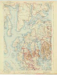
1942 Map of Mount Desert
USGS Topo · Published 1942About this map
Acadia National Park dominates the landscape of this 1940s survey, showing the complex interaction of rugged granite peaks and the Atlantic coastline during the early years of the park's federal management. The map details the island's established maritime communities, including Somesville Mt Desert PO and the harbor towns of Southwest Harbor and Northeast Harbor. A granite-based economy is evidenced by Hall Quarry, while the region's growing role in science and aviation is marked by the Marine Biological Laboratory near Salsbury Cove and the Bar Harbor Airport in Trenton. Local life away from the shore is documented through numerous district schools like The Narrows Sch and rural family burying grounds such as Haynes Cem and the South Surry Cem. The terrain ranges from the low-lying bog of Big Heath to the heights of McFarland Mtn, connected by a network of established roads and the historic Turnpike.
Find a feature on this map
228 named features on this map. Tap any name to fly to it.
Don’t see what you’re looking for? This feature index may not catch every label — zoom into the map to look around manually.
Map Details
Editions of this 1942 Mount Desert Map
5 editions found

Other maps of this area

1900 · Orland
USGS Topo · 1:62,500

1904 · Deer Isle
USGS Topo · 1:62,500

1904 · Mount Desert
USGS Topo · 1:62,500

1904 · Swan Island
USGS Topo · 1:62,500

1904 · Bar Harbor
USGS Topo · 1:62,500

1904 · Bluehill
USGS Topo · 1:62,500

1905 · Penobscot Bay
USGS Topo · 1:125,000

1911 · Ellsworth
USGS Topo · 1:62,500

1930 · Tunk Lake
USGS Topo · 1:48,000

1932 · Tunk Lake
USGS Topo · 1:62,500