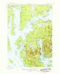
1942 Map of Mount Desert
USGS Topo · Published 1947About this map
Acadia National Park dominates the eastern half of this coastal survey, where the carriage roads and early trail networks of Mount Desert island are meticulously documented. The landscape is defined by the sharp transition from the granite peaks and glacial ponds like Jordan Pond and Eagle Lake to the intricate maritime settlements at the island's fringe. To the north, the Bar Harbor Airport stands near the narrow causeway at The Narrows, while scientific and industrial landmarks such as the Marine Biological Laboratory near Salsbury Cove highlight the area's mid-century role as a research hub.
Find a feature on this map
267 named features on this map. Tap any name to fly to it.
Don’t see what you’re looking for? This feature index may not catch every label — zoom into the map to look around manually.
Map Details
Editions of this 1942 Mount Desert Map
5 editions found

Other maps of this area

1900 · Orland
USGS Topo · 1:62,500

1904 · Deer Isle
USGS Topo · 1:62,500

1904 · Mount Desert
USGS Topo · 1:62,500

1904 · Swan Island
USGS Topo · 1:62,500

1904 · Bar Harbor
USGS Topo · 1:62,500

1904 · Bluehill
USGS Topo · 1:62,500

1905 · Penobscot Bay
USGS Topo · 1:125,000

1911 · Ellsworth
USGS Topo · 1:62,500

1930 · Tunk Lake
USGS Topo · 1:48,000

1932 · Tunk Lake
USGS Topo · 1:62,500