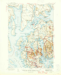
1942 Map of Mount Desert
USGS Topo · Published 1947About this map
Acadia National Park and the rugged coastline of Mount Desert Island are documented here in detail following surveys from the late 1930s. The landscape is defined by the deep indentation of Somes Sound and a network of freshwater bodies such as Eagle Lake, Jordan Pond, and Echo Lake. This era shows the island's dual character as both a prestigious summer destination and a working maritime community, with scientific and infrastructure hubs like the Biological Laboratory at Salsbury Cove and the Bar Harbor Airport established near West Trenton. Local life is anchored in coastal villages like Southwest Harbor, Northeast Harbor, and Somesville, where the presence of the Tremont School and various neighborhood cemeteries—including the South Surry Cem and Leland Cem—provide essential points for genealogical research. The map also traces the Old Turnpike and numerous coastal points like The Ovens and Hadley Point, capturing the transition from traditional maritime travel to modern land-based tourism.
Find a feature on this map
231 named features on this map. Tap any name to fly to it.
Don’t see what you’re looking for? This feature index may not catch every label — zoom into the map to look around manually.
Map Details
Editions of this 1942 Mount Desert Map
5 editions found

Other maps of this area

1900 · Orland
USGS Topo · 1:62,500

1904 · Deer Isle
USGS Topo · 1:62,500

1904 · Mount Desert
USGS Topo · 1:62,500

1904 · Swan Island
USGS Topo · 1:62,500

1904 · Bar Harbor
USGS Topo · 1:62,500

1904 · Bluehill
USGS Topo · 1:62,500

1905 · Penobscot Bay
USGS Topo · 1:125,000

1911 · Ellsworth
USGS Topo · 1:62,500

1930 · Tunk Lake
USGS Topo · 1:48,000

1932 · Tunk Lake
USGS Topo · 1:62,500