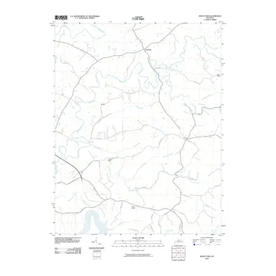
2010 Map of Mount Eden
USGS Topo · Published 2010About this map
The Salt River carves through the southern landscape of this Spencer County region, defining a topography marked by prominent elevations like Elk Hill and Possum Ridge. Settlement patterns are centered around Southville and the high ground of Pea Ridge, connected by a network of rural routes such as Hickory Ridge Rd and June Cull Rd. The terrain is deeply dissected by a dense drainage system, including the winding course of Beech Creek and its many tributaries like Little Beech Creek and Dutchman Branch. The presence of labels like Brief Ridge and various named branches indicates a long history of local land identification. This 2010 edition reflects the modern rural character of the area, where ancient watercourses like Guist Creek and Tenmile Creek continue to shape the movement and placement of modern roads and homesteads.
Find a feature on this map
38 named features on this map. Tap any name to fly to it.
Don’t see what you’re looking for? This feature index may not catch every label — zoom into the map to look around manually.
Map Details
Editions of this 2010 Mount Eden Map
This is the sole edition of this map. No revisions or reprints were ever made.
Other maps of this area

1923 · Waddy
USGS Topo · 1:48,000

1925 · Mount Eden
USGS Topo · 1:48,000

1927 · Mount Eden
USGS Topo · 1:62,500

1929 · Taylorsville
USGS Topo · 1:62,500

1952 · Ashbrook
USGS Topo · 1:24,000

1952 · Chaplin
USGS Topo · 1:24,000

1953 · Bloomfield
USGS Topo · 1:24,000
1954 · Glensboro
USGS Topo · 1:24,000

1954 · Taylorsville
USGS Topo · 1:24,000
1954 · Waddy
USGS Topo · 1:24,000