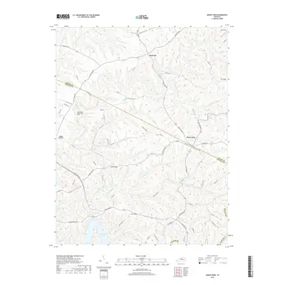
2019 Map of Mount Eden
USGS Topo · Published 2019About this map
Mount Eden sits at the intersection of several significant local arteries, including Mount Eden Rd and Mill Rd, marking a community centered on the ridge lines of the central Kentucky landscape. This area is defined by its dramatic relief, where the high ground of Possum Ridge, Pea Ridge, and Brier Ridge dictates the winding paths of the road network. To the south, the waters of Taylorsville Lake reach into the valleys, fed by tributaries like Thatcher Br and Dutchman Br. The geography here reveals a clear pattern of hilltop settlement and upland farming, with the Little Mount International Airport and Miles Field occupying rare stretches of level ground. Small hamlets like Southville and Little Mount anchor the northern and western sections of the map, while drainage systems such as Guist Creek and Beech Creek carve the deep hollows that characterize this part of Shelby and Spencer Counties.
Find a feature on this map
71 named features on this map. Tap any name to fly to it.
Don’t see what you’re looking for? This feature index may not catch every label — zoom into the map to look around manually.
Map Details
Editions of this 2019 Mount Eden Map
This is the sole edition of this map. No revisions or reprints were ever made.
Other maps of this area

1923 · Waddy
USGS Topo · 1:48,000

1925 · Mount Eden
USGS Topo · 1:48,000

1927 · Mount Eden
USGS Topo · 1:62,500

1929 · Taylorsville
USGS Topo · 1:62,500

1952 · Ashbrook
USGS Topo · 1:24,000

1952 · Chaplin
USGS Topo · 1:24,000

1953 · Bloomfield
USGS Topo · 1:24,000
1954 · Glensboro
USGS Topo · 1:24,000

1954 · Taylorsville
USGS Topo · 1:24,000
1954 · Waddy
USGS Topo · 1:24,000