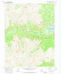
1967 Map of Mount Elbert
USGS Topo · Published 1975About this map
Mount Elbert, the highest point in Colorado, dominates this 1967 survey of the high Sawatch Range. The map details a landscape defined by the legacies of hard-rock mining and the management of high-altitude water resources within the San Isabel National Forest. Concentrated along the slopes of Bull Hill and Echo Canyon, numerous claims such as the Golden Fleece Mine, Fidelity Mine, and Last Chance Mine speak to the era's prospecting history.
Find a feature on this map
62 named features on this map. Tap any name to fly to it.
Don’t see what you’re looking for? This feature index may not catch every label — zoom into the map to look around manually.
Map Details
Editions of this 1967 Mount Elbert Map
4 editions found
Other maps of this area

1889 · Leadville
USGS Topo · 1:125,000

1891 · Leadville
USGS Topo · 1:125,000

1909 · Mount Jackson
USGS Topo · 1:125,000

1911 · Mount Jackson
USGS Topo · 1:125,000

1934 · Taylor Park
USGS Topo · 1:62,500

1935 · Mount Elbert
USGS Topo · 1:62,500

1937 · Taylor Park
USGS Topo · 1:62,500

1938 · Mount Elbert
USGS Topo · 1:62,500

1939 · Mount Elbert
USGS Topo · 1:62,500

1942 · Leadville
USGS Topo · 1:125,000