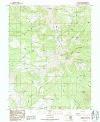
1986 Map of Mount Ellen
USGS Topo · Published 1987About this map
Mount Ellen dominates this high-altitude landscape in Garfield County, serving as the focal point for a complex network of ridges and drainages during the mid-1980s. The terrain is defined by prominent divides such as North Summit Ridge and Pistol Ridge, which separate various water systems including the Head of Bullfrog and the South Fork Pistol Creek. Evidence of resource exploration is scattered throughout the region, particularly around Bromide Basin and Kimble and Turner Peak, where numerous prospects and prospect pits indicate a history of mining activity.
Find a feature on this map
58 named features on this map. Tap any name to fly to it.
Don’t see what you’re looking for? This feature index may not catch every label — zoom into the map to look around manually.
Map Details
Editions of this 1986 Mount Ellen Map
2 editions found
Other maps of this area

1885 · San Rafael
USGS Topo · 1:250,000

1886 · Henry Mountains
USGS Topo · 1:250,000

1892 · Henry Mountains
USGS Topo · 1:250,000

1952 · Mount Ellen 4 SW
USGS Topo · 1:24,000

1952 · Mt Pennell 2 NE
USGS Topo · 1:24,000

1952 · Mt Hillers
USGS Topo · 1:62,500

1952 · Mt. Ellen 4 NW
USGS Topo · 1:24,000

1952 · Mt Pennell 1 NW
USGS Topo · 1:24,000

1952 · Bull Mountain
USGS Topo · 1:62,500

1953 · Mt Pennell
USGS Topo · 1:62,500