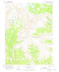
1965 Map of Mount Emmons
USGS Topo · Published 1975About this map
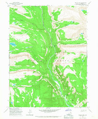
Mount Emmons dominates this high-altitude landscape in the Ashley National Forest, rising above a complex network of alpine glacial basins. The 1965 survey reveals a primitive wilderness defined by the Timothy Lakes cluster to the west and the Chain Lakes to the east, connected by a network of pack trails and jeep trails. These trails provide the only access to remote water bodies like Lake Atwood and the smaller B-29 Lake. The terrain transitions from the high peaks down into Krebs Basin and toward Jackson Park, with numerous tributaries including Swift Creek, Owl Creek, and Crow Creek draining the snow-melt. This map captures the area as it was managed for backcountry recreation and forest preservation in the mid-1960s, documenting the specific drainage patterns and high-country passes such as Roberts Pass before more modern land-use changes.
Find a feature on this map
39 named features on this map. Tap any name to fly to it.
Don’t see what you’re looking for? This feature index may not catch every label — zoom into the map to look around manually.
Map Details
Editions of this 1965 Mount Emmons Map
3 editions found
Other maps of this area

1885 · Uinta
USGS Topo · 1:250,000

1905 · Gilbert Peak
USGS Topo · 1:125,000

1906 · Gilbert Peak
USGS Topo · 1:125,000

1954 · Salt Lake City
USGS Topo · 1:250,000

1958 · Salt Lake City
USGS Topo · 1:250,000

1960 · Salt Lake City
USGS Topo · 1:250,000

1965 · Mount Emmons
USGS Topo · 1:24,000
1965 · Heller Lake
USGS Topo · 1:24,000
1965 · Kings Peak
USGS Topo · 1:24,000
1965 · Bollie Lake
USGS Topo · 1:24,000