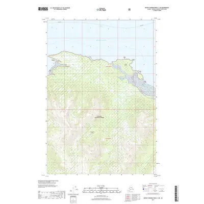
2017 Map of Mount Fairweather A-1 NE
USGS Topo · Published 2017About this map
Chichagof Island and the sprawling expanse of the Tongass National Forest dominate this maritime landscape along the northern Pacific coast. The geography is defined by a complex network of waterways, including the open waters of the Gulf of Alaska and the protected channels of the Icy Strait and South Passage. Coastal features such as Gull Cove, Goose Island, and Quartz Point highlight the intricate shoreline, where the land meets the sea in a series of inlets and promontories like Mud Bay. A marked Ferry Route cutting across the northern straits signifies the vital role of waterborne transit in this roadless wilderness. The map details a largely undeveloped environment, where the federal protections of the TNF preserve the wilderness character of the Alexander Archipelago's northern reaches.
Find a feature on this map
13 named features on this map. Tap any name to fly to it.
Don’t see what you’re looking for? This feature index may not catch every label — zoom into the map to look around manually.
Map Details
Editions of this 2017 Mount Fairweather A-1 NE Map
This is the sole edition of this map. No revisions or reprints were ever made.
Other maps of this area

1948 · Juneau B-6
USGS Topo · 1:63,360

1948 · Mount Fairweather B-1
USGS Topo · 1:63,360

1948 · Mount Fairweather A-1
USGS Topo · 1:63,360

1951 · Juneau
USGS Topo · 1:250,000

1951 · Juneau A-6
USGS Topo · 1:63,360

1951 · Mt Fairweather
USGS Topo · 1:250,000

1954 · Mount Fairweather A-1
USGS Topo · 1:63,360

1961 · Mt Fairweather
USGS Topo · 1:250,000

1962 · Juneau
USGS Topo · 1:250,000
2000 · Juneau A-6
USGS Topo · 1:63,360