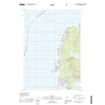
2017 Map of Mount Fairweather A-2 SW
USGS Topo · Published 2017About this map
Yakobi Island dominates this coastal landscape where the Gulf of Alaska meets the intricate shorelines of the Tongass National Forest. The map documents a complex maritime interface, characterized by deep inlets like Hoktaheen Cove and Bingham Cove that reach into the interior. Elevation rises sharply from the Pacific to landmarks such as Bingham Peak, while freshwater features like Hoktaheen Lake and Surge Lake sit tucked behind the rocky littoral. The presence of the Hoonah-Angoon Census Area boundary cutting through the open waters of the Pacific Ocean illustrates the administrative divisions of this coastal wilderness. The lack of roads or settlements underscores the preservation of this area as part of the national forest system, where drainage patterns like Hoktaheen Cr define the movement of water from the peaks to the sea.
Find a feature on this map
17 named features on this map. Tap any name to fly to it.
Don’t see what you’re looking for? This feature index may not catch every label — zoom into the map to look around manually.
Map Details
Editions of this 2017 Mount Fairweather A-2 SW Map
This is the sole edition of this map. No revisions or reprints were ever made.
Other maps of this area

1948 · Mount Fairweather A-2
USGS Topo · 1:63,360

1948 · Sitka D-8
USGS Topo · 1:63,360

1950 · Sitka D-8
USGS Topo · 1:63,360

1951 · Mt Fairweather
USGS Topo · 1:250,000

1951 · Sitka
USGS Topo · 1:250,000

1952 · Sitka
USGS Topo · 1:250,000
1961 · Mount Fairweather A-3
USGS Topo · 1:63,360

1961 · Mt Fairweather
USGS Topo · 1:250,000

1964 · Sitka
USGS Topo · 1:250,000
1995 · Sitka D-8
USGS Topo · 1:63,360