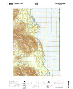
2017 Map of Mount Fairweather B-1 NE
USGS Topo · Published 2017About this map
Glacier Bay National Park defines this coastal landscape where the waters of the Gulf of Alaska meet the protected inlets of the Alexander Archipelago. The intricate shoreline, marked by landmarks such as Rush Point and Point Carolus, illustrates the complex geography of the Fairweather range as it slopes toward the sea. Inland, the map reveals the dense topographical relief typical of this wilderness, while the coastal waters are divided by the Sitakaday Narrows and the Beardslee Entrance. The lack of road infrastructure and human settlements emphasizes the character of this protected area, focusing instead on the hydrographic detail of Glacier Bay and Ripple Cove. Researchers and geographers can observe the intersection of deep-water channels and the steep, glaciated terrain of the Southeast Alaska panhandle during the early twenty-first century.
Find a feature on this map
12 named features on this map. Tap any name to fly to it.
Don’t see what you’re looking for? This feature index may not catch every label — zoom into the map to look around manually.
Map Details
Editions of this 2017 Mount Fairweather B-1 NE Map
This is the sole edition of this map. No revisions or reprints were ever made.
Other maps of this area

1948 · Juneau B-6
USGS Topo · 1:63,360

1948 · Juneau C-6
USGS Topo · 1:63,360

1948 · Mount Fairweather B-1
USGS Topo · 1:63,360

1948 · Mount Fairweather C-1
USGS Topo · 1:63,360

1949 · Mount Fairweather C-1
USGS Topo · 1:63,360

1950 · Juneau C-6
USGS Topo · 1:63,360

1951 · Juneau
USGS Topo · 1:250,000

1951 · Mt Fairweather
USGS Topo · 1:250,000

1961 · Mt Fairweather
USGS Topo · 1:250,000

1962 · Juneau
USGS Topo · 1:250,000