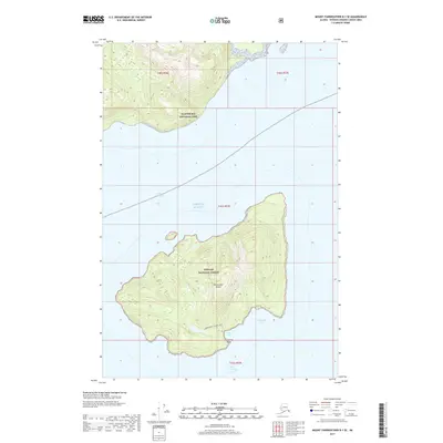
2017 Map of Mount Fairweather B-1 SE
USGS Topo · Published 2017About this map
Lemesurier Island dominates the maritime landscape of this coastal survey, situated within the protected reaches of the Tongass National Forest. The island's geography is defined by its interior Lemesurier Island Lake and several prominent coastal indentations, including Jacks Cove and Willoughby Cove to the southeast. To the north, the boundary of Glacier Bay National Park extends across the North Passage, marking a significant intersection of federal conservation lands. The surrounding waters of the Gulf of Alaska are separated by the island, with the South Passage flanking its southern shore near Iceberg Point. This topographical study illustrates the isolation of the island’s terrain and its relationship to the surrounding deep-water passages of the Alaskan panhandle.
Find a feature on this map
14 named features on this map. Tap any name to fly to it.
Don’t see what you’re looking for? This feature index may not catch every label — zoom into the map to look around manually.
Map Details
Editions of this 2017 Mount Fairweather B-1 SE Map
This is the sole edition of this map. No revisions or reprints were ever made.
Other maps of this area

1948 · Juneau B-6
USGS Topo · 1:63,360

1948 · Mount Fairweather B-1
USGS Topo · 1:63,360

1948 · Mount Fairweather A-1
USGS Topo · 1:63,360

1951 · Juneau
USGS Topo · 1:250,000

1951 · Juneau A-6
USGS Topo · 1:63,360

1951 · Mt Fairweather
USGS Topo · 1:250,000

1954 · Mount Fairweather A-1
USGS Topo · 1:63,360

1961 · Mt Fairweather
USGS Topo · 1:250,000

1962 · Juneau
USGS Topo · 1:250,000
2000 · Juneau A-6
USGS Topo · 1:63,360