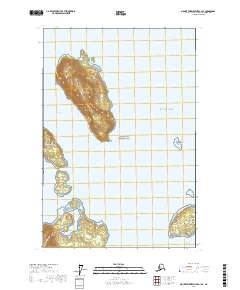
2017 Map of Mount Fairweather C-1 SE
USGS Topo · Published 2017About this map
Willoughby Island dominates the center of this coastal survey, rising sharply above the waters of Whidbey Passage. Located within Glacier Bay National Park, the landscape is defined by its dramatic maritime features and intricate shoreline. The map reveals a cluster of smaller islands to the south, including Netland Island, Lars Island, and Strawberry Island, which guard the entrance to Berg Bay. The proximity of these landmasses creates narrow, navigable corridors like the Sitakaday Narrows and Beardslee Entrance. This 2017 edition illustrates the complex hydrography of the Gulf of Alaska coastline, where prominent points such as Saint James Point and George Point serve as key landmarks for understanding the area's geological and navigational history.
Find a feature on this map
21 named features on this map. Tap any name to fly to it.
Don’t see what you’re looking for? This feature index may not catch every label — zoom into the map to look around manually.
Map Details
Editions of this 2017 Mount Fairweather C-1 SE Map
This is the sole edition of this map. No revisions or reprints were ever made.
Other maps of this area

1948 · Juneau B-6
USGS Topo · 1:63,360

1948 · Juneau C-6
USGS Topo · 1:63,360

1948 · Mount Fairweather B-1
USGS Topo · 1:63,360

1948 · Mount Fairweather C-1
USGS Topo · 1:63,360

1949 · Mount Fairweather C-1
USGS Topo · 1:63,360

1950 · Juneau C-6
USGS Topo · 1:63,360

1951 · Juneau
USGS Topo · 1:250,000

1951 · Mt Fairweather
USGS Topo · 1:250,000

1961 · Mt Fairweather
USGS Topo · 1:250,000

1962 · Juneau
USGS Topo · 1:250,000