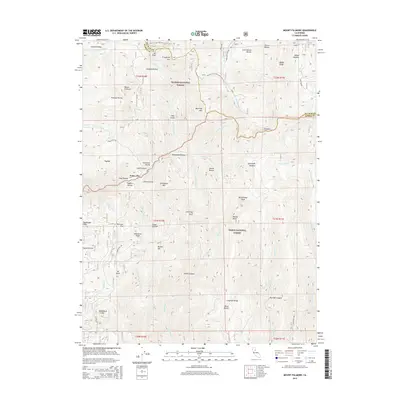
2015 Map of Mount Fillmore
USGS Topo · Published 2015About this map
Pacific Crest National Scenic Trail winds through the high-elevation boundary where the Plumas National Forest meets the Tahoe National Forest. This 2015 survey of the Sierra Nevada crest documents a landscape defined by significant peaks and deep ravines, including Mount Fillmore, Deadwood Peak, and Stafford Mtn. The map reveals a complex network of canyons and gulches, such as Tennessee Ravine and Clarks Canyon, which feed into the Downie River and Canyon Cr. Geographically distinct landmarks like Chimney Rock and Cloud Splitter are situated near the border between Plumas and Sierra counties. Notable access routes like Poker Flat Rd and Saddleback Rd provide context for navigating the drainage systems of Big Grizzly Cr and the W Br Downie River.
Find a feature on this map
70 named features on this map. Tap any name to fly to it.
Don’t see what you’re looking for? This feature index may not catch every label — zoom into the map to look around manually.
Map Details
Editions of this 2015 Mount Fillmore Map
This is the sole edition of this map. No revisions or reprints were ever made.
Other maps of this area

1891 · Downieville
USGS Topo · 1:125,000

1893 · Downieville
USGS Topo · 1:125,000

1895 · Downieville
USGS Topo · 1:125,000

1896 · Downieville
USGS Topo · 1:125,000

1897 · Downieville
USGS Topo · 1:125,000

1937 · Blairsden
USGS Topo · 1:48,000

1943 · Blairsden
USGS Topo · 1:62,500
1950 · Onion Valley
USGS Topo · 1:24,000
1951 · Onion Valley
USGS Topo · 1:24,000
1951 · Mt. Fillmore
USGS Topo · 1:24,000