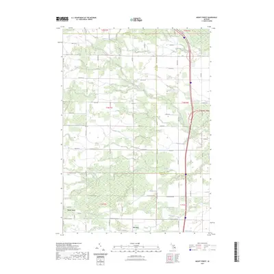
2023 Map of Mount Forest
USGS Topo · Published 2023About this map
The Arenac and Bay County line bisects this landscape, where a dense network of agricultural drainage systems and natural waterways defines the local geography. Significant water features include the Middle Branch Pine River and South Branch Pine River in the north, while the southern reaches are dominated by White Feather Creek and the Saganing River. Small settlements such as Mount Forest and Nine Mile serve as anchor points for a rural road grid that includes M 61 and W Whitefeather Rd. The area is heavily marked by man-made water management features like Sunsmith Drain, Budd Drain, and Saganing Drain, illustrating a long history of land reclamation and drainage for farming. This 2023 survey by the U.S. Geological Survey provides a precise view of the modern rural infrastructure and natural drainage patterns in this part of Michigan.
Find a feature on this map
40 named features on this map. Tap any name to fly to it.
Don’t see what you’re looking for? This feature index may not catch every label — zoom into the map to look around manually.
Map Details
Editions of this 2023 Mount Forest Map
This is the sole edition of this map. No revisions or reprints were ever made.
Other maps of this area

1954 · Traverse City
USGS Topo · 1:250,000

1954 · Midland
USGS Topo · 1:250,000

1954 · Flint
USGS Topo · 1:250,000

1954 · Tawas City
USGS Topo · 1:250,000

1958 · Traverse City
USGS Topo · 1:250,000

1958 · Flint
USGS Topo · 1:250,000

1958 · Tawas City
USGS Topo · 1:250,000

1958 · Midland
USGS Topo · 1:250,000

1959 · Midland
USGS Topo · 1:250,000

1966 · Midland
USGS Topo · 1:250,000
Featured Places
- Mount Forest, MI
- Deep River Township, MI
- Gibson Township, MI
- Mount Forest Township, MI
- Pinconning Township, MI