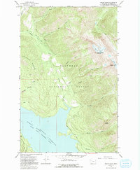
1964 Map of Mount Grant
USGS Topo · Published 1992About this map
The waters of the Hungry Horse Reservoir dominate the southern portion of this landscape, marking a significant engineering presence in the Flathead National Forest. Following the impoundment of the South Fork Flathead River, the map shows the shoreline at a normal pool elevation of 3560 feet, flanked by steep terrain and the Hungry Horse Road. The high alpine environment to the northeast is defined by the permanent ice of Stanton Glacier and Grant Glacier, situated beneath the peaks of Great Northern Mountain and Mount Grant. This 1964 survey captures the area’s remote character, where access is limited to primitive routes like the Pack Trail and Highline Loop Road. Numerous drainages, including Tiger Creek, Mare Creek, and Murray Creek, illustrate the complex hydrology feeding the reservoir from these high-elevation watersheds.
Find a feature on this map
34 named features on this map. Tap any name to fly to it.
Don’t see what you’re looking for? This feature index may not catch every label — zoom into the map to look around manually.
Map Details
Editions of this 1964 Mount Grant Map
2 editions found
Other maps of this area

1914 · Nyack
USGS Topo · 1:125,000

1958 · Felix Peak
USGS Topo · 1:24,000

1960 · Cut Bank
USGS Topo · 1:250,000

1963 · Cut Bank
USGS Topo · 1:250,000

1964 · Cut Bank
USGS Topo · 1:250,000
1964 · Jewel Basin
USGS Topo · 1:24,000

1964 · Nyack
USGS Topo · 1:24,000

1964 · Pinnacle
USGS Topo · 1:24,000

1964 · Stanton Lake
USGS Topo · 1:24,000
1964 · Nyack SW
USGS Topo · 1:24,000