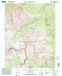
1994 Map of Mount Harvard
USGS Topo · Published 2001About this map
Mount Harvard and the surrounding Collegiate Peaks dominate this high-altitude landscape along the Continental Divide during the mid-1990s. The settlement of Winfield sits in the northern reaches near the Winfield Cemetery, serving as a focal point for the historic mining activity that once defined these gulches. Evidence of this industrial past remains through the Magdalene Mine and various unnamed mines and prospects scattered across the steep slopes.
Find a feature on this map
49 named features on this map. Tap any name to fly to it.
Don’t see what you’re looking for? This feature index may not catch every label — zoom into the map to look around manually.
Map Details
Editions of this 1994 Mount Harvard Map
This is the sole edition of this map. No revisions or reprints were ever made.
Other maps of this area

1889 · Leadville
USGS Topo · 1:125,000

1891 · Leadville
USGS Topo · 1:125,000

1935 · Mount Elbert
USGS Topo · 1:62,500

1938 · Mount Elbert
USGS Topo · 1:62,500

1939 · Mount Elbert
USGS Topo · 1:62,500

1942 · Leadville
USGS Topo · 1:125,000

1955 · Buena Vista
USGS Topo · 1:62,500

1955 · Mount Harvard
USGS Topo · 1:62,500

1956 · Montrose
USGS Topo · 1:250,000

1957 · Leadville
USGS Topo · 1:250,000