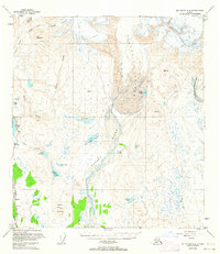
1950 Map of Mount Hayes A-3
USGS Topo · Published 1963About this map
Paxson serves as the primary focal point of this Alaskan interior landscape, situated at a vital junction where the Richardson Highway meets the southern waters of Summit Lake. This mid-century survey reveals a transition from the structured transportation corridor of the highway and its adjacent Landing Strip to the immense glacial systems of the high country. The northern reaches are dominated by the Gulkana Glacier, College Glacier, and Gakona Glacier, which feed a complex network of waterways including College Creek and the Gulkana River.
Find a feature on this map
33 named features on this map. Tap any name to fly to it.
Don’t see what you’re looking for? This feature index may not catch every label — zoom into the map to look around manually.
Map Details
Editions of this 1950 Mount Hayes A-3 Map
3 editions found
Other maps of this area

1949 · Mount Hayes A-4
USGS Topo · 1:63,360

1949 · Gulkana D-3
USGS Topo · 1:63,360

1950 · Mount Hayes
USGS Topo · 1:250,000

1950 · Gulkana D-4
USGS Topo · 1:63,360

1950 · Mount Hayes A-3
USGS Topo · 1:63,360

1951 · Gulkana
USGS Topo · 1:250,000

1951 · Mount Hayes
USGS Topo · 1:250,000

1952 · Gulkana D-3
USGS Topo · 1:63,360

1952 · Mount Hayes A-3
USGS Topo · 1:63,360

1952 · Gulkana D-4
USGS Topo · 1:63,360