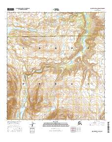
2016 Map of Mount Hayes A-4 NW
USGS Topo · Published 2016About this map
Delta River serves as the central physical corridor in this 2016 survey, cutting through the Alaskan interior where the Southeast Fairbanks Census Area meets the Valdez-Cordova Census Area. The landscape is dominated by complex drainage patterns and significant elevations, anchored by the prominent Sugarloaf Mtn. Glacial and mountain runoff is captured by several named tributaries, including Eureka Creek to the north and the winding paths of Cabin Cr, Garret Cr, and Wildhorse Cr. The map captures a largely untouched wilderness at the start of the twenty-first century, defined by its hydrological network and the stark boundary between these two administrative census regions.
Find a feature on this map
13 named features on this map. Tap any name to fly to it.
Don’t see what you’re looking for? This feature index may not catch every label — zoom into the map to look around manually.
Map Details
Editions of this 2016 Mount Hayes A-4 NW Map
This is the sole edition of this map. No revisions or reprints were ever made.
Other maps of this area

1949 · Mount Hayes A-4
USGS Topo · 1:63,360

1949 · Mount Hayes A-5
USGS Topo · 1:63,360

1950 · Mount Hayes
USGS Topo · 1:250,000

1951 · Mount Hayes
USGS Topo · 1:250,000

1951 · Mt. Hayes B-5
USGS Topo · 1:63,360

1952 · Mount Hayes A-4
USGS Topo · 1:63,360

1952 · Mount Hayes B-4
USGS Topo · 1:63,360
1952 · Mount Hayes A-5
USGS Topo · 1:63,360

1954 · Mount Hayes B-4
USGS Topo · 1:63,360

1955 · Mount Hayes
USGS Topo · 1:250,000