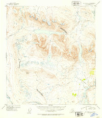
1952 Map of Mount Hayes A-5
USGS Topo · Published 1953About this map
Glacial lakes and braided river systems dominate this Alaskan landscape, where the Maclaren River cuts through the southwestern corner and the complex Tangle Lakes chain emerges in the southeast. Surveyed just after the war, the topography reflects a moment of early infrastructure development, noted by a road segment marked as Under Construction and an Approximate Boundary Road trailing through the center. High alpine benchmarks like Vabm Boulder 4716 and Vabm Wild 4372 define the high points of the terrain, overlooking deep notches such as Landmark Gap. The map also delineates the legal geography of the territory, showing the boundary between the Fourth Judicial Division and the Third Judicial Division, providing a detailed view of the wilderness before later 20th-century expansion changed the character of the region.
Find a feature on this map
13 named features on this map. Tap any name to fly to it.
Don’t see what you’re looking for? This feature index may not catch every label — zoom into the map to look around manually.
Map Details
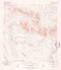
Editions of this 1952 Mount Hayes A-5 Map
3 editions found
Other maps of this area

1949 · Mount Hayes A-4
USGS Topo · 1:63,360

1949 · Mount Hayes A-5
USGS Topo · 1:63,360

1950 · Mount Hayes
USGS Topo · 1:250,000

1950 · Gulkana D-4
USGS Topo · 1:63,360

1950 · Mount Hayes A-6
USGS Topo · 1:63,360

1951 · Gulkana
USGS Topo · 1:250,000

1951 · Mount Hayes
USGS Topo · 1:250,000

1951 · Gulkana D-6
USGS Topo · 1:63,360

1951 · Mount Hayes B-6
USGS Topo · 1:63,360

1951 · Mt. Hayes B-5
USGS Topo · 1:63,360