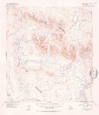
1952 Map of Mt. Hayes A-5
USGS Topo · Published 1953About this map
The Maclaren River and the complex basin of the Tangle Lakes dominate this interior landscape, which served as a critical corridor during the early 1950s. This survey records a significant moment in the region's transportation history, showing a route labeled Under Construction heading toward Paxson, marking the development of what would become the Denali Highway.
Find a feature on this map
14 named features on this map. Tap any name to fly to it.
Don’t see what you’re looking for? This feature index may not catch every label — zoom into the map to look around manually.
Map Details
Editions of this 1952 Mt. Hayes A-5 Map
3 editions found
Other maps of this area

1949 · Mount Hayes A-4
USGS Topo · 1:63,360

1949 · Mount Hayes A-5
USGS Topo · 1:63,360

1950 · Mount Hayes
USGS Topo · 1:250,000

1950 · Gulkana D-4
USGS Topo · 1:63,360

1950 · Mount Hayes A-6
USGS Topo · 1:63,360

1951 · Gulkana
USGS Topo · 1:250,000

1951 · Mount Hayes
USGS Topo · 1:250,000

1951 · Gulkana D-6
USGS Topo · 1:63,360

1951 · Mount Hayes B-6
USGS Topo · 1:63,360

1951 · Mt. Hayes B-5
USGS Topo · 1:63,360