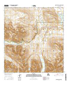
2016 Map of Mount Hayes A-5 NE
USGS Topo · Published 2016About this map
Sevenmile Lake lies at the heart of this high-altitude landscape, where the administrative boundary between the Southeast Fairbanks and Valdez-Cordova Census Areas bisects the terrain. The geography is defined by significant mountain passes and water drainage systems, including the prominent Glacier Gap and Landmark Gap. These natural corridors have historically served as critical transit points through the northern reaches of the Amphitheater Mountains. To the northeast, Wildhorse Cr carves through the undulating topography, illustrating the drainage patterns that characterize this subarctic environment. The map provides a detailed view of the township and range system across this remote region, highlighting how physical landmarks like gaps and lakes dictate the sparse human footprint in the Alaskan interior.
Find a feature on this map
12 named features on this map. Tap any name to fly to it.
Don’t see what you’re looking for? This feature index may not catch every label — zoom into the map to look around manually.
Map Details
Editions of this 2016 Mount Hayes A-5 NE Map
This is the sole edition of this map. No revisions or reprints were ever made.
Other maps of this area

1949 · Mount Hayes A-4
USGS Topo · 1:63,360

1949 · Mount Hayes A-5
USGS Topo · 1:63,360

1950 · Mount Hayes
USGS Topo · 1:250,000

1951 · Mount Hayes
USGS Topo · 1:250,000

1951 · Mt. Hayes B-5
USGS Topo · 1:63,360

1952 · Mount Hayes A-4
USGS Topo · 1:63,360

1952 · Mount Hayes B-4
USGS Topo · 1:63,360
1952 · Mount Hayes A-5
USGS Topo · 1:63,360

1954 · Mount Hayes B-4
USGS Topo · 1:63,360

1955 · Mount Hayes
USGS Topo · 1:250,000