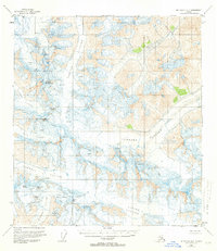
1955 Map of Mount Hayes B-3
USGS Topo · Published 1963About this map
Gerstle Glacier and Johnson Glacier dominate this mid-century survey of the Alaska Range, where ice and elevation define the landscape. Based on 1954 aerial photography, the map documents a complex system of ice flows including the Canwell Glacier and Gulkana Glacier, punctuated by prominent peaks such as White Princess and Mt Gakona. The survey meticulously identifies hazardous terrain features like the Gabriel Icefall and Moore Icefall, along with numerous fields of Crevasses that mark the slow movement of the ice sheets. This technical mapping provides a foundational record of the region's glacial extent and high-altitude geography, featuring distinctive summits like Old Snowy, Black Cap, and Snow White that serve as primary landmarks for climbers and geologists in this corner of the Mount Hayes quadrangle.
Find a feature on this map
24 named features on this map. Tap any name to fly to it.
Don’t see what you’re looking for? This feature index may not catch every label — zoom into the map to look around manually.
Map Details
Editions of this 1955 Mount Hayes B-3 Map
3 editions found

Other maps of this area

1949 · Mount Hayes A-4
USGS Topo · 1:63,360

1950 · Mount Hayes
USGS Topo · 1:250,000

1950 · Mount Hayes C-4
USGS Topo · 1:63,360

1950 · Mount Hayes A-3
USGS Topo · 1:63,360

1951 · Mount Hayes
USGS Topo · 1:250,000

1952 · Mount Hayes A-3
USGS Topo · 1:63,360

1952 · Mount Hayes A-4
USGS Topo · 1:63,360

1952 · Mount Hayes C-4
USGS Topo · 1:63,360

1952 · Mount Hayes B-4
USGS Topo · 1:63,360

1954 · Mount Hayes C-3
USGS Topo · 1:63,360