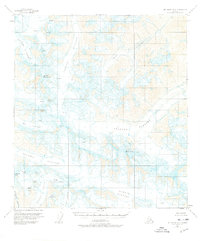
1955 Map of Mount Hayes B-3
USGS Topo · Published 1976About this map
Castner Glacier and Gerstle Glacier dominate a high-altitude landscape defined by ice and rock in this mid-1950s survey. The map details an extensive network of ice flows including the Johnson Glacier and Gakona Glacier, which spill from the slopes of prominent peaks like Mt Gakona and Old Snowy. The presence of numerous crevasses and icefalls, such as the Gabriel Icefall and Moore Icefall, highlights the active nature of this alpine environment before the onset of modern glacial recession. Peaks such as White Princess, M Ladies Mtn, and Skull Peak anchor the ridgelines that divide these massive ice fields. This record captures the intricate drainage patterns where the ice transitions to moving water, most notably at the headwaters of Phelan Creek, providing a foundational view of the region's topography during the mid-century.
Find a feature on this map
28 named features on this map. Tap any name to fly to it.
Don’t see what you’re looking for? This feature index may not catch every label — zoom into the map to look around manually.
Map Details
Editions of this 1955 Mount Hayes B-3 Map
3 editions found

Other maps of this area

1949 · Mount Hayes A-4
USGS Topo · 1:63,360

1950 · Mount Hayes
USGS Topo · 1:250,000

1950 · Mount Hayes C-4
USGS Topo · 1:63,360

1950 · Mount Hayes A-3
USGS Topo · 1:63,360

1951 · Mount Hayes
USGS Topo · 1:250,000

1952 · Mount Hayes A-3
USGS Topo · 1:63,360

1952 · Mount Hayes A-4
USGS Topo · 1:63,360

1952 · Mount Hayes C-4
USGS Topo · 1:63,360

1952 · Mount Hayes B-4
USGS Topo · 1:63,360

1954 · Mount Hayes C-3
USGS Topo · 1:63,360