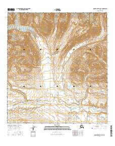
2016 Map of Mount Hayes B-5 SE
USGS Topo · Published 2016About this map
Broxson Gulch serves as a central landmark in this high-altitude landscape of the Alaska Range, where the steep, dramatic topography is defined by narrow drainage systems. This 2016 survey highlights the complex hydrology of the interior, featuring the upper reaches of Eureka Cr and Eureka Creek as they cut through the mountain slopes. The confluence of these water systems with Specimen Cr and the W Fork Rainy Cr illustrates a classic glacial-carved drainage pattern. Land divisions throughout the area are marked by township and range lines including t18s r8e and t19s r9e, which provide the essential survey grid for this remote wilderness. The map is a precise record of water flow and elevation in a region where the terrain dictates both accessibility and the natural paths of the landscape.
Find a feature on this map
9 named features on this map. Tap any name to fly to it.
Don’t see what you’re looking for? This feature index may not catch every label — zoom into the map to look around manually.
Map Details
Editions of this 2016 Mount Hayes B-5 SE Map
This is the sole edition of this map. No revisions or reprints were ever made.
Other maps of this area

1949 · Mount Hayes A-4
USGS Topo · 1:63,360

1949 · Mount Hayes A-5
USGS Topo · 1:63,360

1950 · Mount Hayes
USGS Topo · 1:250,000

1951 · Mount Hayes
USGS Topo · 1:250,000

1951 · Mt. Hayes B-5
USGS Topo · 1:63,360

1952 · Mount Hayes A-4
USGS Topo · 1:63,360

1952 · Mount Hayes B-4
USGS Topo · 1:63,360
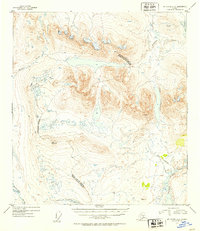
1952 · Mount Hayes A-5
USGS Topo · 1:63,360

1954 · Mount Hayes B-4
USGS Topo · 1:63,360

1955 · Mount Hayes
USGS Topo · 1:250,000