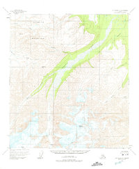
1955 Map of Mount Hayes C-3
USGS Topo · Published 1975About this map
The massive Gerstle Glacier dominates the southern landscape of this mid-century survey, with its icy reach giving way to the braided channels of the Gerstle River. This glacial activity defines the terrain, moving from the high, crevassed fields near Mount Hajdukovich down into a network of drainage basins. To the northwest, the prominent Granite Mountain stands as a primary landmark, flanked by Granite Creek and McCumber Creek.
Find a feature on this map
14 named features on this map. Tap any name to fly to it.
Don’t see what you’re looking for? This feature index may not catch every label — zoom into the map to look around manually.
Map Details
Editions of this 1955 Mount Hayes C-3 Map
3 editions found

Other maps of this area

1950 · Mount Hayes
USGS Topo · 1:250,000

1950 · Mount Hayes D-4
USGS Topo · 1:63,360

1950 · Mount Hayes C-4
USGS Topo · 1:63,360

1951 · Mount Hayes
USGS Topo · 1:250,000

1952 · Mount Hayes D-4
USGS Topo · 1:63,360

1952 · Mount Hayes C-4
USGS Topo · 1:63,360

1952 · Mount Hayes B-4
USGS Topo · 1:63,360

1954 · Mount Hayes C-3
USGS Topo · 1:63,360

1954 · Mount Hayes D-2
USGS Topo · 1:63,360

1954 · Mount Hayes D-3
USGS Topo · 1:63,360