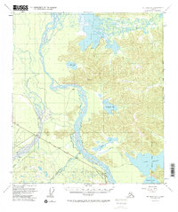
1955 Map of Mount Hayes D-2
USGS Topo · Published 1963About this map
Tanana River and the sweeping braided channels of the Gerstle River dominate this mid-century portrait of interior Alaska. The Alaska Highway cuts a definitive line across the southern landscape, serving as the primary corridor for regional travel and industry. Near the intersection of these water and road networks, evidence of local livelihoods appears through labels for a Sawmill and a Quarry, while the George Lake Lodge and scattered Cabins near Healy Lake indicate the area's role in wilderness commerce and habitation.
Find a feature on this map
20 named features on this map. Tap any name to fly to it.
Don’t see what you’re looking for? This feature index may not catch every label — zoom into the map to look around manually.
Map Details
Editions of this 1955 Mount Hayes D-2 Map
2 editions found

Other maps of this area

1950 · Mount Hayes
USGS Topo · 1:250,000

1950 · Big Delta
USGS Topo · 1:250,000

1951 · Big Delta
USGS Topo · 1:250,000

1951 · Mount Hayes
USGS Topo · 1:250,000

1954 · Mount Hayes C-3
USGS Topo · 1:63,360

1954 · Mount Hayes D-2
USGS Topo · 1:63,360

1954 · Mount Hayes D-3
USGS Topo · 1:63,360

1954 · Mount Hayes D-1
USGS Topo · 1:63,360

1954 · Mount Hayes C-1
USGS Topo · 1:63,360

1954 · Big Delta A-2
USGS Topo · 1:63,360