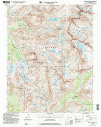
2004 Map of Mount Hilgard
USGS Topo · Published 2007About this map
Mount Hilgard stands as a prominent centerpiece in this high-altitude section of the John Muir Wilderness, where the Sierra Nevada crest forms a jagged boundary between Fresno and Inyo counties. The landscape is defined by an intricate network of glacial basins and alpine lakes, many bearing ursine names such as Big Bear Lake, Little Bear Lake, and Teddy Bear Lake. This area serves as a critical junction for long-distance trekkers, as both the John Muir Trail and the Pacific Crest National Scenic Trail traverse the western portion of the map, crossing through Rosemarie Meadow and over Selden Pass.
Find a feature on this map
98 named features on this map. Tap any name to fly to it.
Don’t see what you’re looking for? This feature index may not catch every label — zoom into the map to look around manually.
Map Details
Editions of this 2004 Mount Hilgard Map
2 editions found
Other maps of this area

1912 · Mt. Goddard
USGS Topo · 1:125,000

1947 · Mariposa
USGS Topo · 1:250,000

1948 · Mariposa
USGS Topo · 1:250,000

1948 · Mt. Goddard
USGS Topo · 1:62,500

1949 · Mt. Tom
USGS Topo · 1:62,500

1951 · Mt. Tom
USGS Topo · 1:62,500

1951 · Mt. Goddard
USGS Topo · 1:62,500

1952 · Mt. Goddard
USGS Topo · 1:62,500

1953 · Mt Abbot
USGS Topo · 1:62,500

1953 · Blackcap Mtn
USGS Topo · 1:62,500