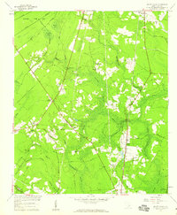
1957 Map of Mount Holly
USGS Topo · Published 1959About this map
Laurel Swamp and Cypress Swamp dominate the landscape north of Charleston, where the Lowcountry's intricate hydrology is marked by extensive wetlands and family-named branches. The mid-century era is characterized by small rural settlements and religious centers such as Mount Holly and Strawberry, the latter serving as a point along the Atlantic Coast Line railroad. This survey reveals a pattern of dispersed community life centered around local landmarks like the Varner Sch and numerous country churches, including Groomsville Ch and Smyrna Ch.
Find a feature on this map
54 named features on this map. Tap any name to fly to it.
Don’t see what you’re looking for? This feature index may not catch every label — zoom into the map to look around manually.
Map Details
Editions of this 1957 Mount Holly Map
4 editions found
Other maps of this area

1919 · Ladson
USGS Topo · 1:21,120

1919 · Summerville
USGS Topo · 1:48,000

1919 · Cordesville
USGS Topo · 1:48,000

1919 · Melgrove
USGS Topo · 1:21,120

1920 · Ravenels
USGS Topo · 1:62,500

1920 · Summerville
USGS Topo · 1:62,500

1940 · Melgrove
USGS Topo · 1:24,000

1943 · Ladson
USGS Topo · 1:24,000

1944 · Ravenels
USGS Topo · 1:62,500

1944 · Summerville
USGS Topo · 1:62,500