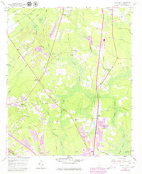
1957 Map of Mount Holly
USGS Topo · Published 1979About this map
Laurel Swamp and Huckhole Swamp dominate the low-lying terrain of Berkeley County, where early infrastructure follows the higher ground between these expansive wetlands. The map illustrates a landscape transitioning from rural crossroads like Carnes Crossroad to the emerging suburban footprints near Goose Creek. Educational and spiritual centers serve as key local anchors, including the Varner Sch and numerous country churches such as St Johns Ch and Smyrna Ch. Evidence of the area's older transport and industrial history is visible in the Old Railroad Grade and the Seaboard Coast Line, which skirts the edge of Canterhill. Small family landmarks and local settlements like Driggerstown and Groomsville provide essential details for genealogists tracing mid-century residency patterns before modern development reshaped the region.
Find a feature on this map
47 named features on this map. Tap any name to fly to it.
Don’t see what you’re looking for? This feature index may not catch every label — zoom into the map to look around manually.
Map Details
Editions of this 1957 Mount Holly Map
4 editions found
Other maps of this area

1919 · Ladson
USGS Topo · 1:21,120

1919 · Summerville
USGS Topo · 1:48,000

1919 · Cordesville
USGS Topo · 1:48,000

1919 · Melgrove
USGS Topo · 1:21,120

1920 · Ravenels
USGS Topo · 1:62,500

1920 · Summerville
USGS Topo · 1:62,500

1940 · Melgrove
USGS Topo · 1:24,000

1943 · Ladson
USGS Topo · 1:24,000

1944 · Ravenels
USGS Topo · 1:62,500

1944 · Summerville
USGS Topo · 1:62,500