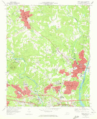
1970 Map of Mount Holly
USGS Topo · Published 1972About this map
The Catawba River and its South Fork define the industrial and residential corridors of eastern Gaston County during this era of rapid suburban expansion. Following the Seaboard Coast Line and Southern Ry, a chain of textile-focused settlements including Stanley, Lowell, and McAdenville shows a transition from traditional mill towns to a broader regional layout. The landscape is dotted with community anchors like Belmont Abbey College and Holbrook High Sch, while more specialized sites like the WBTV Radio Tower on Spencer Mountain highlight the area's role in regional communications.
Find a feature on this map
81 named features on this map. Tap any name to fly to it.
Don’t see what you’re looking for? This feature index may not catch every label — zoom into the map to look around manually.
Map Details
Editions of this 1970 Mount Holly Map
This is the sole edition of this map. No revisions or reprints were ever made.
Other maps of this area

1905 · Charlotte
USGS Topo · 1:48,000

1907 · Charlotte
USGS Topo · 1:62,500

1914 · Gastonia
USGS Topo · 1:48,000

1916 · Gastonia
USGS Topo · 1:62,500

1941 · Charlotte
USGS Topo · 1:125,000

1942 · Charlotte
USGS Topo · 1:125,000

1947 · Clover
USGS Topo · 1:62,500

1948 · Paw Creek
USGS Topo · 1:24,000

1948 · Charlotte West
USGS Topo · 1:24,000

1949 · Clover
USGS Topo · 1:62,500