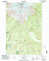
1996 Map of Mount Hood South
USGS Topo · Published 1998About this map
The massive southern slopes of Mount Hood dominate this landscape, where the high-altitude environment is defined by glaciers such as Reid, Zigzag, and White River Glacier. The map documents a complex overlay of historic transportation routes and modern recreational infrastructure during the late twentieth century. The legendary Barlow Road traces its way through the mountain's lower reaches, intersecting with the Pacific Crest National Scenic Trail near Barlow Pass. Human presence is concentrated around the historic Timberline Lodge and the settlement of Government Camp, while the Mount Hood Meadows Ski Area and Snowbunny Lodge highlight the area's development for winter sports. Deeper in the timber, landmarks like the Pioneer Womans Grave at Summit Meadows and the Paradise Park Shelter provide tangible links to the region's long history of traversal and mountaineering.
Find a feature on this map
76 named features on this map. Tap any name to fly to it.
Don’t see what you’re looking for? This feature index may not catch every label — zoom into the map to look around manually.
Map Details
Editions of this 1996 Mount Hood South Map
This is the sole edition of this map. No revisions or reprints were ever made.
Other maps of this area

1924 · Mount Hood
USGS Topo · 1:125,000

1927 · Mount Hood
USGS Topo · 1:125,000

1953 · The Dalles
USGS Topo · 1:250,000

1956 · The Dalles
USGS Topo · 1:250,000

1956 · High Rock
USGS Topo · 1:62,500

1956 · Mt. Wilson
USGS Topo · 1:62,500

1957 · The Dalles
USGS Topo · 1:250,000

1962 · Cathedral Ridge
USGS Topo · 1:24,000
1962 · Badger Lake
USGS Topo · 1:24,000
1962 · Government Camp
USGS Topo · 1:24,000