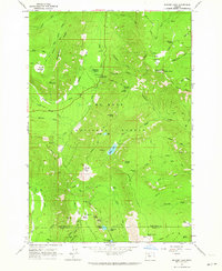
1962 Map of Badger Lake
USGS Topo · Published 1964About this map
The Mt Hood National Forest dominates this high-altitude landscape, where the headwaters of the East Fork Hood River and White River originate amidst a network of ridges and meadows. Historically utilized for fire monitoring and forest management, the area is punctuated by remote outposts such as the Robinhood Guard Sta and Valley View Cabin. The topography is characterized by prominent landmarks like Gunsight Butte and Badger Butte, while glacial and alpine features like Badger Lake, Boulder Lake, and Elk Meadows provide essential water sources for the complex drainage system of Gumjuwac Creek and Dog River. This survey captures the transition from primitive pack routes to established forest service roads, including the Bennett Pass Road, reflecting the increasing accessibility for both forestry and mid-century recreation in the Oregon Cascades.
Find a feature on this map
64 named features on this map. Tap any name to fly to it.
Don’t see what you’re looking for? This feature index may not catch every label — zoom into the map to look around manually.
Map Details
Editions of this 1962 Badger Lake Map
3 editions found
Other maps of this area

1924 · Mount Hood
USGS Topo · 1:125,000

1927 · Mount Hood
USGS Topo · 1:125,000

1930 · Dufur
USGS Topo · 1:125,000

1934 · Dufur
USGS Topo · 1:125,000

1953 · The Dalles
USGS Topo · 1:250,000

1956 · The Dalles
USGS Topo · 1:250,000

1956 · Mt. Wilson
USGS Topo · 1:62,500

1957 · The Dalles
USGS Topo · 1:250,000

1962 · Rock Creek Reservoir
USGS Topo · 1:24,000

1962 · Cathedral Ridge
USGS Topo · 1:24,000