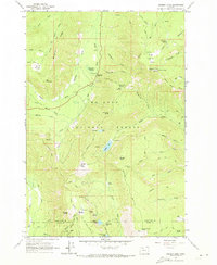
1962 Map of Badger Lake
USGS Topo · Published 1973About this map
Mt Hood National Forest terrain dominates this 1962 survey, revealing a landscape of high-altitude ridges and isolated mountain stations. The area is defined by the high elevations of Bluegrass Ridge and Elk Mountain, where the East Fork Hood River carves through the central valley. For local historians and researchers, the map provides precise locations for remote outposts like the Robinhood Guard Sta and Brooks Meadow Guard Sta, alongside high-country shelters such as Valley View Cabin. A network of early pack trails and forest roads, including the Gumjuwac Trail and Bennett Pass Road, connects several alpine water bodies such as Badger Lake and Jean Lake. These details illustrate the mid-century infrastructure managed by the forest service for fire lookout and recreational access.
Find a feature on this map
66 named features on this map. Tap any name to fly to it.
Don’t see what you’re looking for? This feature index may not catch every label — zoom into the map to look around manually.
Map Details
Editions of this 1962 Badger Lake Map
3 editions found
Other maps of this area

1924 · Mount Hood
USGS Topo · 1:125,000

1927 · Mount Hood
USGS Topo · 1:125,000

1930 · Dufur
USGS Topo · 1:125,000

1934 · Dufur
USGS Topo · 1:125,000

1953 · The Dalles
USGS Topo · 1:250,000

1956 · The Dalles
USGS Topo · 1:250,000

1956 · Mt. Wilson
USGS Topo · 1:62,500

1957 · The Dalles
USGS Topo · 1:250,000

1962 · Rock Creek Reservoir
USGS Topo · 1:24,000

1962 · Cathedral Ridge
USGS Topo · 1:24,000