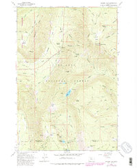
1962 Map of Badger Lake
USGS Topo · Published 1980About this map
Mount Hood National Forest dominates this high-altitude landscape, where the Hood River and Wasco county line divides a rugged network of ridges and glacial drainages. The area is defined by its recreation and forestry infrastructure, notably the Robinhood Guard Sta and Valley View Cabin, alongside several established campgrounds near Badger Lake and Boulder Lake. The map reveals a transition in land use management, as the Mount Hood Wilderness boundary protects the western reaches near Elk Mountain. Extensive trail systems like the Gumjuwac Trail and Badger Creek Trail connect distinctive volcanic features including Gunsight Butte and Badger Butte. Notable alpine meadows such as Horsethief Meadows and Elk Meadows indicate the seasonal grazing or botanical character of these high basins during the early 1960s.
Find a feature on this map
76 named features on this map. Tap any name to fly to it.
Don’t see what you’re looking for? This feature index may not catch every label — zoom into the map to look around manually.
Map Details
Editions of this 1962 Badger Lake Map
3 editions found
Other maps of this area

1924 · Mount Hood
USGS Topo · 1:125,000

1927 · Mount Hood
USGS Topo · 1:125,000

1930 · Dufur
USGS Topo · 1:125,000

1934 · Dufur
USGS Topo · 1:125,000

1953 · The Dalles
USGS Topo · 1:250,000

1956 · The Dalles
USGS Topo · 1:250,000

1956 · Mt. Wilson
USGS Topo · 1:62,500

1957 · The Dalles
USGS Topo · 1:250,000

1962 · Rock Creek Reservoir
USGS Topo · 1:24,000

1962 · Cathedral Ridge
USGS Topo · 1:24,000