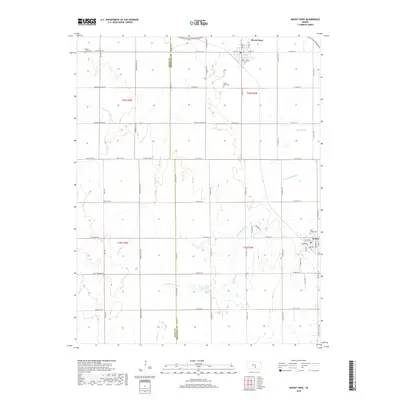
2018 Map of Mount Hope
USGS Topo · Published 2018About this map
Mount Hope and Andale anchor the northeast and southeast corners of this agricultural landscape along the border of Reno and Sedgwick Counties. The terrain is defined by the subtle drainage patterns of the Big Slough and the S Fork Big Slough, which weave through the section-line grid of the Kansas plains. Local history is preserved in several burial grounds, including the Mount Hope Cem near the town center and the Saint Joseph Cem situated on the outskirts of Andale. Further west, the Haven Priest Cem serves as a small landmark near Castleton Rd. The map detail captures the transition from town streets like N Ohio St and E Main St to the expansive rural sections marked by family-named routes such as Rayl Rd and Worthington Rd.
Find a feature on this map
55 named features on this map. Tap any name to fly to it.
Don’t see what you’re looking for? This feature index may not catch every label — zoom into the map to look around manually.
Map Details
Editions of this 2018 Mount Hope Map
This is the sole edition of this map. No revisions or reprints were ever made.
Other maps of this area

1889 · Cheney
USGS Topo · 1:125,000

1891 · Cheney
USGS Topo · 1:125,000

1901 · Cheney
USGS Topo · 1:125,000

1955 · Wichita
USGS Topo · 1:250,000

1958 · Wichita
USGS Topo · 1:250,000

1958 · Patterson
USGS Topo · 1:24,000
1958 · Bentley
USGS Topo · 1:24,000
1958 · Colwich
USGS Topo · 1:24,000

1959 · Mount Hope
USGS Topo · 1:24,000
1961 · Haven
USGS Topo · 1:24,000