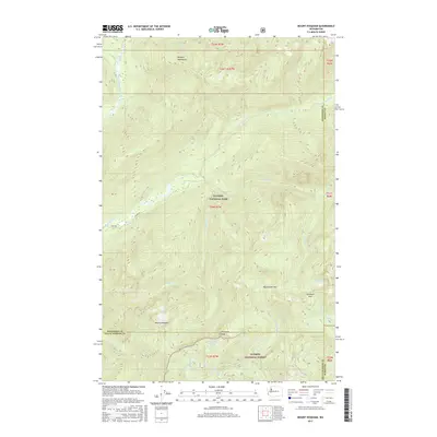
2017 Map of Mount Hoquiam
USGS Topo · Published 2017About this map
Mount Hoquiam stands at the center of this high-elevation landscape, where the boundaries of Olympic National Park and Olympic National Forest meet. The area is defined by the headwaters of several major regional river systems, including the Quinault River, Wynoochee River, and the South Fork Skokomish River. This 2017 survey shows the intricate network of peaks and passes that form the Olympic Mountains interior, such as Wynoochee Pass and Sundown Pass. High-mountain water bodies like Lake Connie, Lake Sundown, and Discovery Lake are prominent landmarks for those navigating the backcountry. While much of the terrain is accessible only by trail, the S Shore Rd provides a point of entry along the southwestern edge near the Quinault valley, marking the transition from managed forest lands to the protected wilderness of the national park.
Find a feature on this map
31 named features on this map. Tap any name to fly to it.
Don’t see what you’re looking for? This feature index may not catch every label — zoom into the map to look around manually.
Map Details
Editions of this 2017 Mount Hoquiam Map
This is the sole edition of this map. No revisions or reprints were ever made.
Other maps of this area

1921 · Satsop
USGS Topo · 1:62,500

1938 · Mt Constance
USGS Topo · 1:125,000

1947 · Mt. Steel
USGS Topo · 1:62,500

1947 · Mt Christie
USGS Topo · 1:62,500

1950 · Mt Christie
USGS Topo · 1:62,500

1950 · Mt. Steel
USGS Topo · 1:62,500

1953 · Mt Tebo
USGS Topo · 1:62,500

1955 · Grisdale
USGS Topo · 1:62,500

1958 · Seattle
USGS Topo · 1:250,000

1962 · Seattle
USGS Topo · 1:250,000