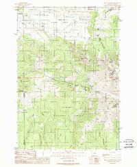
1988 Map of Mount Jefferson
USGS Topo · Published 1988About this map
The Montana Idaho Continental Divide carves a high-altitude boundary across this terrain, where the northern slopes of the Centennial Mountains meet the high plains of the Centennial Valley. Significant land management efforts are evident throughout the landscape, most notably the United States Sheep Experiment Station and the eastern edge of the Red Rock Lakes Nat Wildlife Rfg. These federal designations underscore the region's importance for both agricultural research and conservation at the headwaters of Red Rock Creek.
Find a feature on this map
41 named features on this map. Tap any name to fly to it.
Don’t see what you’re looking for? This feature index may not catch every label — zoom into the map to look around manually.
Map Details
Editions of this 1988 Mount Jefferson Map
This is the sole edition of this map. No revisions or reprints were ever made.
Other maps of this area

1950 · Upper Red Rock Lake
USGS Topo · 1:62,500

1955 · Ashton
USGS Topo · 1:250,000

1958 · Ashton
USGS Topo · 1:250,000

1960 · Ashton
USGS Topo · 1:250,000

1964 · Island Park Dam
USGS Topo · 1:24,000

1964 · Targhee Peak
USGS Topo · 1:24,000

1964 · Sawtell PK
USGS Topo · 1:24,000

1964 · Henrys Lake
USGS Topo · 1:62,500
1965 · Icehouse Creek
USGS Topo · 1:24,000

1965 · Sheridan Reservoir
USGS Topo · 1:24,000