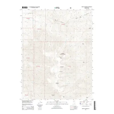
2014 Map of Mount Jefferson
USGS Topo · Published 2014About this map
The high-elevation peaks of the Toquima Range dominate this interior portion of the Toiyabe National Forest. The map is centered on the massive alpine massif of Mt Jefferson, featuring its primary landmarks: the North Summit, Mid Summit, and South Summit. This rugged Great Basin landscape is defined by steep drainage systems such as Slaughterhouse Canyon and Bucks Canyon, which fall away from the high summits toward the surrounding basins.
Find a feature on this map
35 named features on this map. Tap any name to fly to it.
Don’t see what you’re looking for? This feature index may not catch every label — zoom into the map to look around manually.
Map Details
Editions of this 2014 Mount Jefferson Map
This is the sole edition of this map. No revisions or reprints were ever made.
Other maps of this area

1907 · Tonopah
USGS Topo · 1:250,000

1908 · Tonopah
USGS Topo · 1:250,000

1956 · Tonopah
USGS Topo · 1:250,000

1959 · Tonopah
USGS Topo · 1:250,000

1962 · Tonopah
USGS Topo · 1:250,000

1971 · Corcoran Canyon
USGS Topo · 1:24,000
1971 · Jet Spring
USGS Topo · 1:24,000
1971 · Northumberland Pass
USGS Topo · 1:24,000
1971 · Carvers NE
USGS Topo · 1:24,000

1971 · Jefferson
USGS Topo · 1:24,000