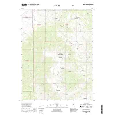
2018 Map of Mount Jefferson
USGS Topo · Published 2018About this map
The high ridges of the Toquima Range dominate this portion of Nye County, where the massive profile of Mt Jefferson rises above the surrounding canyons. Within the Toiyabe National Forest, the mountain is delineated by several distinct peaks including the North Summit Mt Jefferson, Mid Summit Mt Jefferson, and South Summit. These high-altitude points provide the headwaters for numerous drainage systems such as Moores Creek and Pine Creek.
Find a feature on this map
45 named features on this map. Tap any name to fly to it.
Don’t see what you’re looking for? This feature index may not catch every label — zoom into the map to look around manually.
Map Details
Editions of this 2018 Mount Jefferson Map
This is the sole edition of this map. No revisions or reprints were ever made.
Other maps of this area

1907 · Tonopah
USGS Topo · 1:250,000

1908 · Tonopah
USGS Topo · 1:250,000

1956 · Tonopah
USGS Topo · 1:250,000

1959 · Tonopah
USGS Topo · 1:250,000

1962 · Tonopah
USGS Topo · 1:250,000

1971 · Corcoran Canyon
USGS Topo · 1:24,000
1971 · Jet Spring
USGS Topo · 1:24,000
1971 · Northumberland Pass
USGS Topo · 1:24,000
1971 · Carvers NE
USGS Topo · 1:24,000

1971 · Jefferson
USGS Topo · 1:24,000