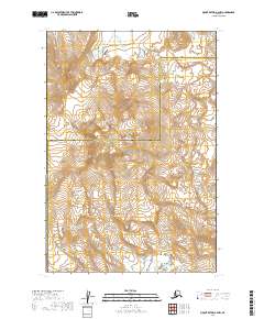
2019 Map of Mount Katmai A-4 NW
USGS Topo · Published 2019About this map
Katmai National Park encompasses this volcanic landscape, dominated by the expansive Mt Mageik and the geological legacy of the Valley of Ten Thousand Smokes. The terrain is defined by the high peaks of the Buttress Range and the Kejulik Mountains, where the headwaters of Martin Creek and Alagogshak Cr originate. In the northern reaches, the aptly named River Lethe winds through the valley floor, overseen by Mt Cerberus. This area marks a critical junction of geography at Katmai Pass, where the boundary between the Lake and Peninsula Borough and Kodiak Island Borough bisects the mountain peaks. A significant Mageik Landslide is also documented in the southeastern corner, illustrating the dynamic and shifting nature of this protected wilderness.
Find a feature on this map
19 named features on this map. Tap any name to fly to it.
Don’t see what you’re looking for? This feature index may not catch every label — zoom into the map to look around manually.
Map Details
Editions of this 2019 Mount Katmai A-4 NW Map
This is the sole edition of this map. No revisions or reprints were ever made.
Other maps of this area

1948 · Mt Katmai
USGS Topo · 1:250,000

1951 · Mt Katmai
USGS Topo · 1:250,000

1951 · Mount Katmai B-4
USGS Topo · 1:63,360

1951 · Mount Katmai A-4
USGS Topo · 1:63,360

1951 · Mount Katmai B-5
USGS Topo · 1:63,360

1951 · Mount Katmai A-5
USGS Topo · 1:63,360
1953 · Mount Katmai B-5
USGS Topo · 1:63,360

1964 · Mt. Katmai
USGS Topo · 1:250,000
2019 · Mount Katmai A-4 SW
USGS Topo · 1:25,000
2019 · Mount Katmai A-4 SE
USGS Topo · 1:25,000