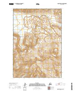
2019 Map of Mount Katmai A-5 NE
USGS Topo · Published 2019About this map
Katmai National Park encompasses this entire stretch of Alaskan wilderness, characterized by the dramatic rise of the Buttress Range in the northeast and the Kejulik Mountains to the southwest. The landscape is defined by its glacial hydrology, with the headwaters of Angle Creek cutting across the northern reaches while the Kejulik River drains the southern slopes. This 2019 survey documents the intricate topography of the Lake and Peninsula Borough, showing how the drainage patterns follow deep glacial valleys between these prominent ranges. The map provides a detailed look at the township and range divisions across the park's interior, from t22s r38w down to t24s r37w, where high-altitude peaks give way to braided stream beds.
Find a feature on this map
11 named features on this map. Tap any name to fly to it.
Don’t see what you’re looking for? This feature index may not catch every label — zoom into the map to look around manually.
Map Details
Editions of this 2019 Mount Katmai A-5 NE Map
This is the sole edition of this map. No revisions or reprints were ever made.
Other maps of this area

1948 · Mt Katmai
USGS Topo · 1:250,000

1951 · Mt Katmai
USGS Topo · 1:250,000

1951 · Mount Katmai B-4
USGS Topo · 1:63,360

1951 · Mount Katmai A-4
USGS Topo · 1:63,360

1951 · Mount Katmai B-5
USGS Topo · 1:63,360

1951 · Mount Katmai A-5
USGS Topo · 1:63,360
1953 · Mount Katmai B-5
USGS Topo · 1:63,360

1964 · Mt. Katmai
USGS Topo · 1:250,000
2019 · Mount Katmai A-4 NW
USGS Topo · 1:25,000
2019 · Mount Katmai A-5 NW
USGS Topo · 1:25,000