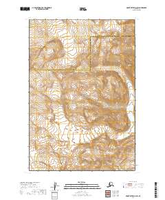
2019 Map of Mount Katmai B-2 SW
USGS Topo · Published 2019About this map
Katmai National Park dominates this remote landscape, where the administrative lines of the Lake and Peninsula Borough and Kodiak Island Borough meet in the high Alaskan wilderness. This survey captures a region defined by dynamic glacial activity and high-elevation terrain, with the Serpent Tongue Glacier as the primary ice feature in the northern reaches of the sheet. The map illustrates the complex topography typical of the Alaska Peninsula, providing a detailed record of the glacial margins and contour elevations that characterize the national park's interior. This 2019 documentation is particularly valuable for researchers tracking changes in the ice mass and landforms of the Aleutian Range.
Find a feature on this map
7 named features on this map. Tap any name to fly to it.
Don’t see what you’re looking for? This feature index may not catch every label — zoom into the map to look around manually.
Map Details
Editions of this 2019 Mount Katmai B-2 SW Map
This is the sole edition of this map. No revisions or reprints were ever made.
Other maps of this area

1948 · Mt Katmai
USGS Topo · 1:250,000

1951 · Mt Katmai
USGS Topo · 1:250,000

1951 · Mount Katmai A-3
USGS Topo · 1:63,360

1951 · Mount Katmai A-2
USGS Topo · 1:63,360

1951 · Mount Katmai B-3
USGS Topo · 1:63,360

1951 · Mount Katmai B-2
USGS Topo · 1:63,360

1964 · Mt. Katmai
USGS Topo · 1:250,000
2019 · Mount Katmai B-3 SE
USGS Topo · 1:25,000
2019 · Mount Katmai B-2 NW
USGS Topo · 1:25,000
2019 · Mount Katmai A-3 NE
USGS Topo · 1:25,000