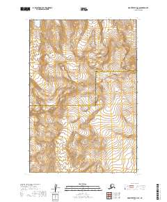
2019 Map of Mount Katmai B-3 SE
USGS Topo · Published 2019About this map
Katmai National Park defines this corner of the Alaska Peninsula, where the landscape is shaped by massive glacial formations and high peaks. The map reveals the intricate drainage patterns flowing away from the Serpent Tongue Glacier, which dominates the northern portion of the quadrangle. In the southern half, the terrain rises toward Noisy Mtn, while Snowy Mtn stands as a prominent landmark to the northeast. This area sits at a political crossroads, marked by the boundary between Lake and Peninsula Borough and Kodiak Island Borough. The survey detail emphasizes the dynamic nature of the glacial environment, showing the fine topographical shifts across the ice and the steep, unnamed ridges that separate these protected wilderness corridors.
Find a feature on this map
9 named features on this map. Tap any name to fly to it.
Don’t see what you’re looking for? This feature index may not catch every label — zoom into the map to look around manually.
Map Details
Editions of this 2019 Mount Katmai B-3 SE Map
This is the sole edition of this map. No revisions or reprints were ever made.
Other maps of this area

1948 · Mt Katmai
USGS Topo · 1:250,000

1951 · Mt Katmai
USGS Topo · 1:250,000

1951 · Mount Katmai A-3
USGS Topo · 1:63,360

1951 · Mount Katmai A-2
USGS Topo · 1:63,360

1951 · Mount Katmai B-3
USGS Topo · 1:63,360

1951 · Mount Katmai B-2
USGS Topo · 1:63,360

1964 · Mt. Katmai
USGS Topo · 1:250,000
2019 · Mount Katmai B-2 NW
USGS Topo · 1:25,000
2019 · Mount Katmai A-3 NE
USGS Topo · 1:25,000
2019 · Mount Katmai B-3 NE
USGS Topo · 1:25,000