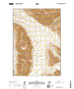
2019 Map of Mount Katmai B-4 SW
USGS Topo · Published 2019About this map
Valley of Ten Thousand Smokes defines this section of Katmai National Park, where the volcanic landscape of the Alaska Peninsula remains etched by high-altitude drainages and dramatic peaks. The central ash-filled valley is flanked by the Buttress Range to the west and the prominent heights of Baked Mtn and Falling Mtn to the east. Water systems including the River Lethe and Knife Creek cut through the volcanic deposits, while Mt Cerberus stands as a sentinel at the southern reaches of the valley floor. This 2019 survey provides a precise look at the modern topography of this geologic landmark, documenting the way wind and water have carved the volcanic tuff since the historic 1912 eruption that created the valley.
Find a feature on this map
15 named features on this map. Tap any name to fly to it.
Don’t see what you’re looking for? This feature index may not catch every label — zoom into the map to look around manually.
Map Details
Editions of this 2019 Mount Katmai B-4 SW Map
This is the sole edition of this map. No revisions or reprints were ever made.
Other maps of this area

1948 · Mt Katmai
USGS Topo · 1:250,000

1951 · Mt Katmai
USGS Topo · 1:250,000

1951 · Mount Katmai B-4
USGS Topo · 1:63,360

1951 · Mount Katmai A-4
USGS Topo · 1:63,360

1951 · Mount Katmai B-5
USGS Topo · 1:63,360

1951 · Mount Katmai A-5
USGS Topo · 1:63,360
1953 · Mount Katmai B-5
USGS Topo · 1:63,360

1964 · Mt. Katmai
USGS Topo · 1:250,000
2019 · Mount Katmai A-4 NW
USGS Topo · 1:25,000
2019 · Mount Katmai B-4 NE
USGS Topo · 1:25,000