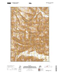
2019 Map of Mount Katmai C-1 SW
USGS Topo · Published 2019About this map
Katmai National Park encompasses the majority of this remote Alaskan landscape, where the terrain is defined by dramatic elevation changes and significant water systems. The Big River drains the northern reaches of the quadrangle, carving through the high country before the land slopes toward the southern boundary marked by the Ninagiak River. This area serves as a critical boundary between the Lake and Peninsula Borough and Kodiak Island Borough, illustrating the administrative divisions within the wilderness. The survey traces the complex hydrography of the region during a period of modern mapping, capturing the untouched character of the drainage basins and ridgelines as they appeared in the early twenty-first century.
Find a feature on this map
8 named features on this map. Tap any name to fly to it.
Don’t see what you’re looking for? This feature index may not catch every label — zoom into the map to look around manually.
Map Details
Editions of this 2019 Mount Katmai C-1 SW Map
This is the sole edition of this map. No revisions or reprints were ever made.
Other maps of this area

1948 · Mt Katmai
USGS Topo · 1:250,000

1951 · Mt Katmai
USGS Topo · 1:250,000

1951 · Mount Katmai C-2
USGS Topo · 1:63,360

1951 · Mount Katmai C-1
USGS Topo · 1:63,360

1951 · Mount Katmai B-1
USGS Topo · 1:63,360

1951 · Mount Katmai B-2
USGS Topo · 1:63,360
1953 · Mount Katmai C-2
USGS Topo · 1:63,360

1964 · Mt. Katmai
USGS Topo · 1:250,000
2019 · Mount Katmai C-1 SE
USGS Topo · 1:25,000
2019 · Mount Katmai C-1 NE
USGS Topo · 1:25,000