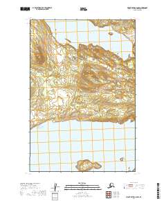
2019 Map of Mount Katmai C-5 NW
USGS Topo · Published 2019About this map
Katmai National Park preserves a vast wilderness landscape defined by significant water bodies and intricate topography. This 2019 survey captures the narrow land bridge and varied elevations separating Lake Coville in the north from the expansive Naknek Lake to the south. The southern portion of the map is dominated by the Bay of Islands, where the shoreline of Naknek Lake breaks into a complex network of small landmasses and inlets. The terrain between these lakes rises through a series of ridges and valleys, illustrating the dramatic geological transitions of the Alaska Peninsula. The presence of these major glacial lakes suggests the historic and ecological importance of the region for salmon migration and local wildlife habitats within the protected park boundaries.
Find a feature on this map
11 named features on this map. Tap any name to fly to it.
Don’t see what you’re looking for? This feature index may not catch every label — zoom into the map to look around manually.
Map Details
Editions of this 2019 Mount Katmai C-5 NW Map
This is the sole edition of this map. No revisions or reprints were ever made.
Other maps of this area

1948 · Mt Katmai
USGS Topo · 1:250,000

1951 · Mt Katmai
USGS Topo · 1:250,000

1951 · Mount Katmai C-6
USGS Topo · 1:63,360

1951 · Mount Katmai D-5
USGS Topo · 1:63,360

1951 · Mount Katmai C-5
USGS Topo · 1:63,360

1951 · Mount Katmai D-6
USGS Topo · 1:63,360
1953 · Mount Katmai C-5
USGS Topo · 1:63,360

1964 · Mt. Katmai
USGS Topo · 1:250,000
2019 · Mount Katmai C-5 SW
USGS Topo · 1:25,000
2019 · Mount Katmai D-6 SE
USGS Topo · 1:25,000