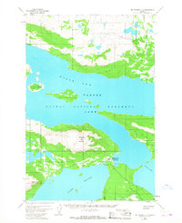
1951 Map of Mount Katmai C-6
USGS Topo · Published 1968About this map
Katmai National Monument is defined by the expansive waterways of the Alaska Peninsula, where the North Arm and Iliuk Arm of Naknek Lake meet. Centered on the topography of Dumpling Mountain, the landscape reflects a transition between deep glacial lakes and rugged peaks. The presence of the Brooks Camp Ranger Station Seaplane Base on the shores of Brooks Lake highlights the area's reliance on air travel for access and monitoring during the early 1950s.
Find a feature on this map
11 named features on this map. Tap any name to fly to it.
Don’t see what you’re looking for? This feature index may not catch every label — zoom into the map to look around manually.
Map Details
Editions of this 1951 Mount Katmai C-6 Map
3 editions found
Other maps of this area

1948 · Mt Katmai
USGS Topo · 1:250,000

1951 · Mt Katmai
USGS Topo · 1:250,000

1951 · Mount Katmai C-6
USGS Topo · 1:63,360

1951 · Mount Katmai B-6
USGS Topo · 1:63,360

1951 · Naknek D-1
USGS Topo · 1:63,360

1951 · Naknek B-1
USGS Topo · 1:63,360

1951 · Mount Katmai D-5
USGS Topo · 1:63,360

1951 · Naknek C-1
USGS Topo · 1:63,360

1951 · Mount Katmai C-5
USGS Topo · 1:63,360

1951 · Mount Katmai D-6
USGS Topo · 1:63,360