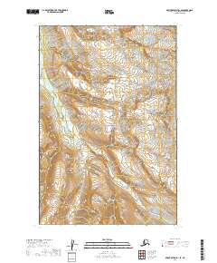
2019 Map of Mount Katmai D-1 SE
USGS Topo · Published 2019About this map
The South Fork Kamishak River defines the drainage patterns of this high-latitude terrain, cutting across several township boundaries within Katmai National Park. This 2019 survey documents a landscape preserved for its wild character and complex geology, where the hydrological network of the South Fork Kamishak River flows toward the coast. The map illustrates the topographic relief of the Alaska Peninsula, focusing on the preservation of the river system and its various tributaries that remain unnamed in this specific quadrangle. This data provides a baseline for tracking environmental changes and water levels in the Kenai Peninsula Borough, far from any established road networks or permanent settlements.
Find a feature on this map
6 named features on this map. Tap any name to fly to it.
Don’t see what you’re looking for? This feature index may not catch every label — zoom into the map to look around manually.
Map Details
Editions of this 2019 Mount Katmai D-1 SE Map
This is the sole edition of this map. No revisions or reprints were ever made.
Other maps of this area

1948 · Mt Katmai
USGS Topo · 1:250,000

1951 · Mt Katmai
USGS Topo · 1:250,000

1951 · Afognak C-6
USGS Topo · 1:63,360

1951 · Mount Katmai D-1
USGS Topo · 1:63,360

1951 · Mount Katmai C-1
USGS Topo · 1:63,360

1951 · Afognak D-6
USGS Topo · 1:63,360

1952 · Afognak
USGS Topo · 1:250,000
1953 · Mount Katmai D-1
USGS Topo · 1:63,360

1964 · Mt. Katmai
USGS Topo · 1:250,000
1983 · Afognak D-6
USGS Topo · 1:63,360